

Buying property is a major financial decision. Most buyers focus on the location, price, size, amenities and documents. However, there is another important area that often gets less attention: land surveying.
A property may look correct on the ground, while its actual boundaries, measurements or location may differ from what is shown in records or plans.
This is where a land survey becomes useful.
A land survey helps establish the physical location, dimensions, boundaries and features of a property. In Telangana, survey and land-record authorities deal with activities such as demarcation, subdivision, survey maps, area corrections and boundary-related matters.
But not every property requires the same type of survey.
There are different types of land surveys, and each serves a different purpose. Understanding them can help property buyers ask the right questions before purchasing a plot, villa, independent house, agricultural land or other property.
What Is a Land Survey?
A land survey is the process of measuring and mapping a property or parcel of land.
Depending on the purpose, a survey can identify:
- Property boundaries
- Land dimensions
- Total area
- Survey numbers
- Subdivision details
- Ground levels
- Existing structures
- Roads and access
- Physical features
- Boundary markers
A professional survey can also help compare the physical property with available maps, plans and land records.
For example, a buyer may see a plot advertised as 200 square yards. A survey can help establish the physical dimensions of that plot and identify its boundaries.
However, a survey should not be treated as a replacement for title verification or legal due diligence.
Why Should Property Buyers Know About Land Surveys?
A property transaction involves more than checking ownership documents.
The physical property also needs attention.
For example, you may encounter:
- A boundary wall that does not match the actual boundary
- A difference between stated and measured dimensions
- An unclear survey numbers
- A subdivided parcel
- Multiple survey numbers forming one property
- Possible encroachment
- Unclear access
- Differences between approved plans and actual construction
Boundary surveys are specifically used for activities such as delimiting, demarcating, delineating and relaying boundaries.
Therefore, understanding the appropriate survey can help buyers conduct better property due diligence.
18 Types of Land Surveys Every Property Buyer Should Know
Let’s look at the different types of land surveys and understand why each one matters.
1. Boundary Survey
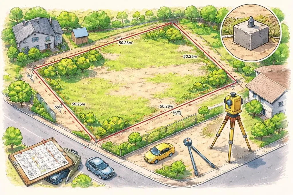
A boundary survey determines or verifies the boundaries of a property.
It focuses on identifying where one property ends and another begins.
A boundary survey may establish:
- Four-side boundaries
- Boundary points
- Boundary markers
- Property dimensions
- Relationship with adjoining properties
- Position of the property on the ground
For example, suppose a plot is shown as 40 feet × 60 feet in a document. A boundary survey can help establish whether the physical boundaries correspond with those dimensions.
Why does it matter to buyers?
A boundary issue can become a serious problem after purchase.
Therefore, buyers of independent plots, houses, agricultural land and individually owned villa plots should understand the property’s actual boundaries.
2. Subdivision Survey
A subdivision survey is carried out when a larger parcel of land is divided into smaller parcels.
For example:
Original Survey Number → Subdivision → Individual Land Parcels
This is common when a large parcel is divided into multiple plots or smaller land parcels.
Telangana’s survey and land-record system includes subdivision-related activities and maintains information relating to survey and sub-survey parcels.
What should buyers check?
If you are buying a subdivided property, check:
- Original survey number
- Subdivision number
- Plot number
- Dimensions
- Area
- Boundaries
- Relevant layout or subdivision plan
Why does it matter?
A buyer should know exactly which portion of the original land parcel is being purchased.
3. Amalgamation Survey
An amalgamation survey is associated with combining two or more adjoining land parcels into a larger parcel.
For example:
Survey Parcel A + Survey Parcel B = Combined Parcel
This can occur when landowners or developers combine adjoining parcels for a larger development.
Why should buyers care?
If a property has been created by combining multiple parcels, buyers should understand:
- Which original parcels were combined
- Their respective survey numbers
- The resulting parcel
- Boundaries
- Total area
- Relevant records and plans
This becomes particularly relevant for larger residential, commercial and development properties.
4. Cadastral Survey
A cadastral survey focuses on land parcels and their relationship with land records.
It can help establish the location and extent of individual parcels and their boundaries.
Telangana’s geospatial land-mapping initiatives include cadastral information, survey numbers, subdivision cadastral data, boundary-stone coordinates and georeferenced revenue maps.
Why is it useful?
For buyers, cadastral information can help connect:
Physical Land → Survey Number → Parcel → Land Records
This is particularly useful when purchasing land where survey numbers and subdivisions are important.
5. Topographic Survey
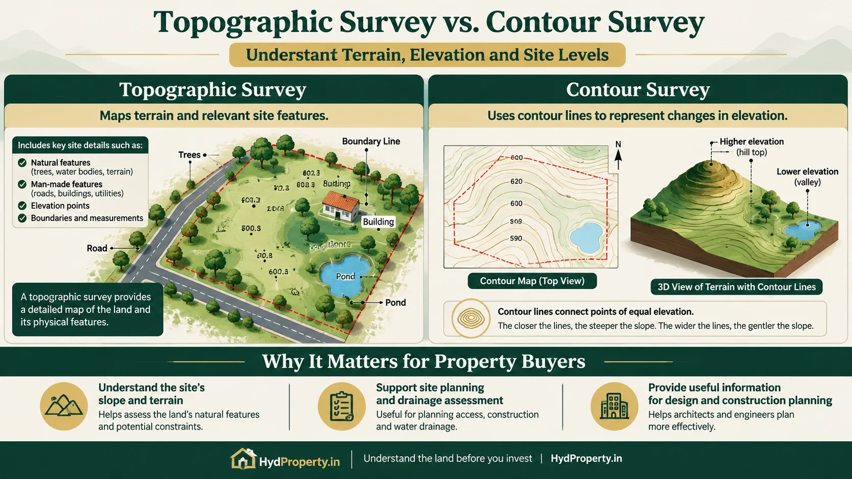
A topographic survey records the physical characteristics of a site.
Unlike a basic boundary survey, it can provide information about the property’s terrain and surrounding physical features.
It may include:
- Ground elevations
- Slopes
- Roads
- Drainage features
- Buildings
- Natural features
- Other site characteristics
Survey of India publishes topographical data containing features such as roads, hydrology, elevation-related information and administrative boundaries.
Why should property buyers know about it?
Topographic surveys are especially useful for:
- Large plots
- Development land
- Construction sites
- Agricultural land
- Properties with significant slopes
For a typical apartment buyer, this type of survey may not be necessary.
6. As-Built Survey
An As-Built Survey records what has actually been constructed on a property.
It can document the physical location and dimensions of:
- Buildings
- Roads
- Structures
- Site features
- Utilities
- Other constructed elements
Why does it matter?
There can sometimes be a difference between what was planned and what was actually constructed.
An as-built survey provides physical information about the completed site.
For example, it can help establish the actual position of a building on a plot.
However, an as-built survey does not by itself prove that construction is legally approved. Approval and compliance should be checked separately.
7. Non-Agricultural Plotted Layout Survey
This is particularly relevant for buyers purchasing residential plots in developed layouts.
When land is developed into a plotted layout, the overall property may be divided into individual plots along with roads, open spaces and other planned areas.
A layout survey can help establish the location and dimensions of:
- Individual plots
- Internal roads
- Open spaces
- Common areas
- Boundaries
- Other layout features
What should buyers check?
Before purchasing a plot, compare the physical property with the relevant layout plan and documents.
Check:
- Survey number
- Plot number
- Plot dimensions
- Road width
- Open spaces
- Layout boundaries
- Relevant approvals
Remember that a survey alone does not establish that a layout is legally approved.
8. Construction / Site Survey
A site survey provides information about the physical characteristics of a property before construction or development.
It can include:
- Site dimensions
- Existing structures
- Ground levels
- Access points
- Roads
- Utility locations
- Other physical features
Why is it important?
If you are buying a plot to construct a house, the site needs to be properly understood before architectural and engineering work begins.
A site survey can provide useful base information for architects, engineers and builders.
9. GPS / GNSS Survey
Modern land surveys can use GPS or GNSS technology to establish accurate geographic coordinates.
These systems can help determine the position of specific points on a property.
For example, surveyors may use GNSS equipment to establish the coordinates of boundary points.
Why should buyers know about it?
GPS/GNSS technology can improve the accuracy and efficiency of modern surveying.
However, buyers should remember one important point:
GPS coordinates alone do not prove ownership.
They are part of the physical and geospatial verification process. Legal ownership still requires separate document verification.
10. Total Station Survey
A Total Station Survey uses electronic surveying equipment to measure angles, distances and positions.
It is widely used for detailed land and construction surveys.
A Total Station can help surveyors determine:
- Distances
- Angles
- Coordinates
- Levels
- Boundary points
- Building positions
Why is it useful?
Total Station surveys can provide detailed measurements for:
- Residential plots
- Buildings
- Construction sites
- Layouts
- Roads
- Development projects
For property buyers, the main benefit is accurate physical measurement.
11. Land Demarcation Survey
Land demarcation means identifying and marking a property’s boundary on the ground.
This can involve identifying boundary points and placing or verifying boundary markers.
Survey of India describes demarcation as identifying an agreed boundary on the ground and establishing markers where necessary.
Telangana’s Survey and Land Records departments also handle demarcation-related activities, including F-Line petitions for demarcation of patta and government lands.
Why should buyers care?
Demarcation becomes particularly important when:
- Boundary stones are missing
- The boundary is unclear
- Adjacent properties are close together
- There is a boundary dispute
- The property has been subdivided
12. Contour Survey
A contour survey focuses on the elevation and levels of the land.
It helps identify how the ground rises or falls across a site.
Contour information can be useful for:
- Building design
- Drainage planning
- Road design
- Site grading
- Large developments
Why does it matter to property buyers?
A plot may appear flat during a quick site visit. However, even small changes in elevation can affect construction and drainage.
For larger properties, understanding the terrain can therefore be useful before development.
13. Route Survey
A route survey is generally used when planning linear infrastructure or development corridors.
It can be associated with:
- Roads
- Pipelines
- Drainage
- Power lines
- Railways
- Other linear infrastructure
Is it important for normal property buyers?
Usually, no.
However, it can become relevant when buying land affected by proposed or existing infrastructure corridors.
For example, buyers of large parcels may need to understand whether roads, utility corridors or other infrastructure affect the property.
14. Hydrographic Survey
A hydrographic survey focuses on water-related features.
It can be used to map:
- Rivers
- Lakes
- Reservoirs
- Canals
- Water bodies
- Water depths
- Underwater features
Why should property buyers know about it?
It may become relevant when purchasing land close to:
- Rivers
- Lakes
- Reservoirs
- Canals
- Large water bodies
For most residential property purchases, this is not a routine survey.
However, understanding nearby water features can still be important for property planning and due diligence.
15. Re-Survey
A re-survey involves surveying land again to update, verify or improve existing survey information.
It may become necessary when:
- Existing records are outdated
- Boundaries need verification
- Survey information needs updating
- Mapping systems are being modernised
- Existing measurements require correction
Telangana’s land-record authorities handle matters including survey-map corrections, area corrections, missing survey numbers and plotting errors.
Why does it matter?
If old records and current physical conditions do not match, additional survey work may be required.
16. Joint Measurement Survey
A joint measurement survey involves measuring a property or boundary with the participation of relevant parties.
It can be useful when there is disagreement about:
- Property dimensions
- Boundaries
- Area
- Shared boundaries
- Land extent
Why is it useful?
When neighbouring landowners disagree about a boundary or measurement, a joint measurement can help establish the physical measurements for further verification.
However, the survey itself should not be treated as a final legal decision in a disputed matter.
17. Encroachment Survey
An encroachment survey is carried out to identify whether any physical occupation appears to extend beyond the relevant property boundary.
For example, an adjoining:
- Wall
- Building
- Fence
- Road extension
- Structure
may appear to occupy part of another property.
A survey can help compare the physical occupation with the relevant boundary information.
Telangana’s geospatial land projects also include activities involving boundary identification and identification of encroachments.
Why should buyers care?
An encroachment issue can become difficult to resolve after purchasing a property.
Therefore, buyers should investigate visible boundary concerns before completing the transaction.
18. Property Verification Survey
A property verification survey is generally used as a broader physical verification exercise.
It may involve checking:
- Property location
- Dimensions
- Boundaries
- Survey number
- Area
- Physical structures
- Adjoining properties
- Access
- Available survey information
Why is it useful?
This type of survey can provide buyers with a clearer understanding of whether the property on the ground corresponds with the information available in plans and records.
However, property verification should ideally be combined with legal and document verification.
Which Land Survey Does a Property Buyer Need?
Not every buyer needs all 18 types of surveys.
The appropriate survey depends on the type of property.
| Property Type | Surveys That May Be Relevant |
| Residential Plot | Boundary, subdivision, demarcation |
| Independent House | Boundary, site, as-built |
| Villa with Individual Land | Boundary, layout, subdivision |
| Plotted Development | Layout, cadastral, boundary |
| Agricultural Land | Boundary, cadastral, demarcation |
| Large Development Land | Boundary, cadastral, topographic |
| Property Under Construction | Site, Total Station, topographic |
| Existing Building | Boundary, as-built, site |
| Property With Boundary Dispute | Boundary, demarcation, joint measurement |
| Land With Possible Encroachment | Boundary, encroachment survey |
| Land Near Water Bodies | Topographic / hydrographic, where applicable |
This table is only a general guide. The exact survey requirements depend on the property, location, records and purpose of the transaction.
Land Survey vs Land Record Verification
These terms are sometimes used interchangeably. However, they are not the same.
A land survey primarily deals with the physical characteristics of the property.
Land-record verification deals with the records associated with the land.
For example:
Land Survey
- Where is the property?
- What are its physical boundaries?
- What are its dimensions?
- What is the measured area?
- Where are the boundary points?
Document Verification
- Who owns the property?
- Is the title clear?
- Are there encumbrances?
- Are the required approvals available?
- Are there restrictions affecting the property?
Therefore, a buyer should not rely on a land survey alone.
What Should Buyers Check After a Land Survey?
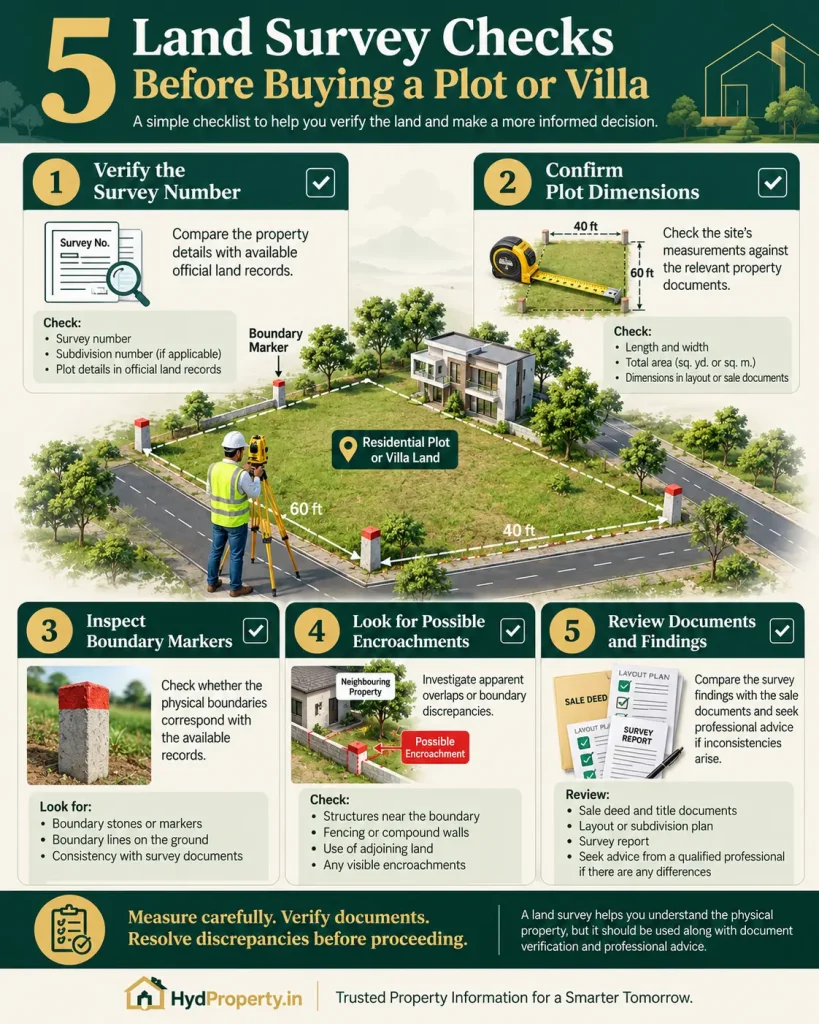
Once the survey is completed, compare the findings with the relevant documents.
Check:
- Survey Number: Does the survey information correspond with the property records?
- Property Area: Does the measured area broadly match the documented area?
- Dimensions: Do the physical length and width match the available plans?
- Boundaries: Do all four sides correspond with the documents?
- Subdivision: If the property comes from a larger parcel, is the subdivision correctly identified?
- Access: Does the property have the access shown in the relevant plans?
- Encroachments: Are there any structures or occupations crossing the relevant boundary?
- Layout: For plotted developments, does the physical plot correspond with the relevant layout plan?
Common Land Survey Mistakes Property Buyers Should Avoid
Relying Only on the Seller’s Measurements
Seller-provided dimensions can be useful, but buyers should independently verify important measurements.
Assuming a Boundary Wall Is the Legal Boundary
A physical wall or fence does not automatically establish the legally recognised property boundary.
Checking Only the Sale Deed
A sale deed is important, but property due diligence can involve several other records, plans and approvals.
Ignoring Survey Subdivisions
A property may be part of a larger original survey parcel. Therefore, subdivision details should not be overlooked.
Assuming GPS Coordinates Prove Ownership
Coordinates establish location. They do not independently establish ownership.
Treating a Survey as Title Verification
A survey cannot replace legal title due diligence.
Land Survey Checklist for Property Buyers
Before buying a plot, villa, independent house or land, consider checking:
- Survey number
- Subdivision details
- Property dimensions
- Total area
- Four-side boundaries
- Boundary markers
- Access road
- Adjoining properties
- Possible encroachments
- Layout plan, where applicable
- Relevant approvals
- Survey drawing/report
- Land records
- Title documents
- Encumbrance information
- Construction approvals, where applicable
Special Considerations for Hyderabad and Telangana Property Buyers
For property buyers in Hyderabad and other parts of Telangana, understanding survey information can be particularly useful.
The Telangana Survey and Land Records system deals with activities including land demarcation, subdivision, village maps, certified copies, survey-map corrections and area corrections.
Telangana’s geospatial mapping initiatives also use cadastral information, survey numbers, subdivision data, boundary coordinates and georeferenced revenue maps.
This means buyers should understand the relationship between:
Survey Number → Subdivision → Physical Parcel → Land Records → Property Documents
For plotted developments and large land parcels, this becomes even more important.
Final Takeaway
A land survey is more than simply measuring a piece of land.
It can help a property buyer understand where the property is, how large it is, where its boundaries are and how its physical characteristics relate to available plans and records.
Different situations require different surveys.
A plot buyer may primarily need boundary and subdivision verification. A large development may require topographic and cadastral surveys. A property with an existing building may benefit from an as-built survey. A property with a boundary issue may require demarcation or joint measurement.
Most importantly, do not treat a land survey as a substitute for legal due diligence.
For a major property purchase, consider looking at the complete picture:
Physical Survey + Land Records + Title Verification + Approval Verification
Taking these checks seriously before purchasing can help buyers identify potential issues early and make a more informed property decision.
Frequently Asked Questions
There is no single survey that is suitable for every property. A boundary survey is particularly relevant when a buyer needs to verify the physical boundaries and dimensions of a plot or land parcel.
It can be useful, particularly when the plot boundaries, dimensions or subdivision details need independent verification.
A subdivision survey deals with dividing a larger land parcel into smaller parcels and establishing the relevant boundaries and measurements.
An amalgamation survey relates to combining two or more adjoining parcels into a larger parcel.
An as-built survey records the physical condition and location of structures or improvements that have actually been constructed on a site.
A cadastral survey focuses on land parcels, their boundaries and their relationship with land records.
A survey can help identify physical occupation that appears to cross a relevant property boundary. Further legal or revenue verification may be required.
No. A survey primarily deals with physical measurements, boundaries and location. Ownership and title require separate document and legal verification.
Total Station equipment can provide detailed measurements of distances, angles and positions. However, the quality of the final survey also depends on the survey methodology, equipment, control points and professional carrying out the work.
It depends on the ownership structure and property documentation. For a villa with an individually identifiable land parcel, boundary and land-parcel verification can be useful.